Saddle Road, Big Island, Hawaii

Kipukas are patches of forest that are spared from destruction in a volcanic eruption and afterward remain as intact habitat islands surrounded by barren expanses of lava. The most accessible examples are along Saddle Road on the southeastern flank of Mauna Kea, part of a landscape that supports the highest diversity of surviving endemic Hawaiian birds, including small populations of four endangered honeycreepers (Palila, Akiapola’au, Hawaii Creeper, and Hawaii Akepa), as well as Hawaiian Hawk, Hawaii Elepaio, Oma’o, and three common honeycreepers (Apapane, I’iwi, and Common Amakihi).
Orientation
Directions
Saddle Road runs through the center of the Big Island over the high pass between Mauna Kea and Mauna Loa. The key segment is the 9.6 miles between Pu’u Huluhulu and the Kaumana Trail, approximately 20 minutes’ drive (18 miles) west of Hilo, or one hour (48 miles) east of Kona.
From Hilo International Airport. Turn left (south) onto Kanoelehua Avenue (which is also the local segment of the Hawaii Belt Road), go one mile, turn right (west) onto Puainako Street (Route 2000). Remain on Puainako through its brief dogleg intersection with Komohana Street at the University of Hawaii – Hilo Campus, then continue west on Puainako which departs Hilo and becomes Saddle Road. Approximately 17 miles from the university, you will reach the Kaumana Trail.
From Kona International Airport. Take Route 19 south for 1.2 miles, turn east on Kaiminani Drive, and go 3.6 miles to the T-junction with the Mamalahoa Highway (also part of the Hawaii Belt Road and Route 190). Turn north on the Belt Road, go 19.4 miles to lower end of Daniel K. Inouye Highway, turn right and take this road for 9.6 miles to its junction with Saddle Road. Turn south onto Saddle Road and go 13.6 miles to Pu’u Huluhulu and the Mauna Kea Access Road.
Birdfinding
There are several sites along Saddle Road to interest visitors. Those who are dedicated to finding the rare endemic honeycreepers will want to focus on the kipukas accessed via the Pu’u O’o Trail and Powerline Road. Some may prefer to stay near the main road and walk one or more of the shorter trails: Kaulana Manu (Kipuka 21), Kaumana, or Pu’u Huluhulu. Some might be drawn to the alpine heights of Mauna Kea.
Pu’u O’o Trail & Powerline Road. The most accessible patches of native forest in the upper elevations of Saddle Road are the kipukas along the Pu’u O’o Trail and Powerline Road—two hiking trails that begin a little less than a mile apart, both around 5,600’ elevation. Driving Saddle Road down from Pu’u Huluhulu, the Pu’u O’o Trailhead is 5.5 miles, and the Powerline Road junction is 6.3 miles.
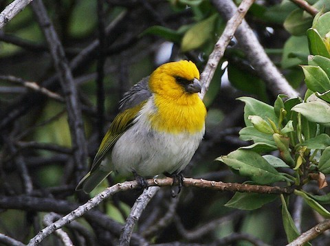
The Palila is uncommon around the Mauna Kea Visitor Center. © Michael Walther
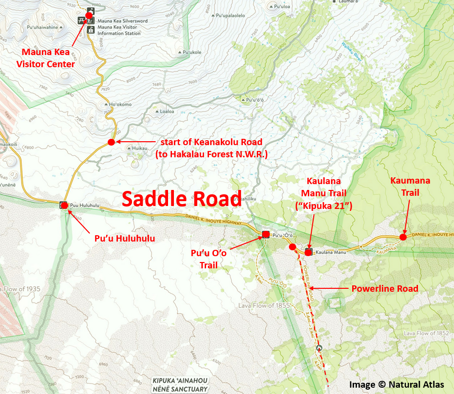
This is one of the few areas of unrestricted public access where the Akiapola’au, Hawaii Creeper, and Hawaii Akepa can be found. There are two main options, which can be boiled down to a trade-off between quantity and quality (roughly speaking).
For reasonable odds of finding all three, the best approach is probably to walk the Powerline Road briskly for about three miles to the “3-Mile Kipuka,” and spend as much time there as needed. That is the only place near Saddle Road where all three of these rarities have been reported regularly. Other likely species include Kalij Pheasant, Hawaii Elepaio, Oma’o, Red-billed Leiothrix, Apapane, I’iwi, and Common Amakihi.
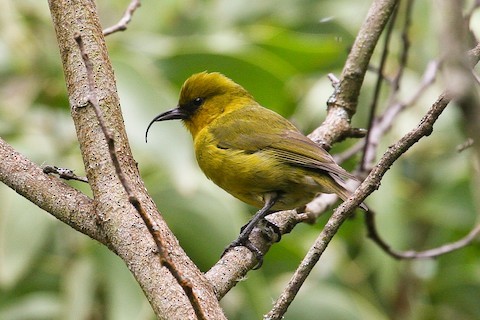
Male Akiapola’au photographed along the Pu’u O’o Trail. © Eric VanderWerf
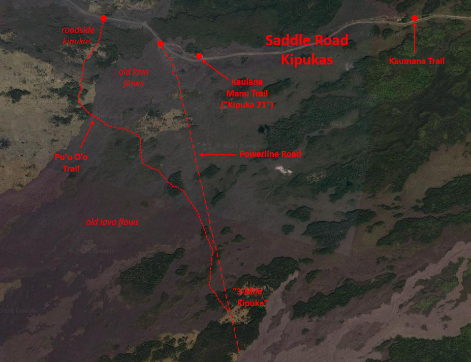
For a less hurried experience and higher odds of finding Akiapola’au, but lower odds of finding Hawaii Creeper and little chance of Hawaii Akepa, take a more leisurely walk along the first two miles of the Pu’u O’o Trail. This will take you through or beside a series of kipukas, and is fairly likely to produce sightings of Hawaiian Goose, Kalij Pheasant, Hawaiian Hawk, Hawaii Elepaio, Oma’o, Red-billed Leiothrix, and the common honeycreepers: Apapane, I’iwi, and Common Amakihi.
It is also possible to walk the Pu’u O’o Trail and Powerline Road as a loop, which many visitors decide to do. It is geographically awkward to describe this as a loop, as both trails head roughly south from Saddle Road and they nearly parallel one another at close range for about two miles. This is a reasonable option, but it may be best to plan one of the other approaches and keep the loop option in mind as an alternative return path.
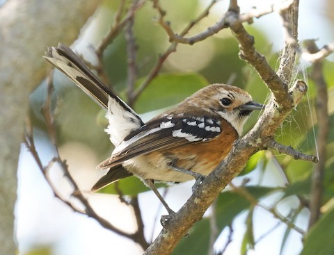
The Hawaii Elepaio is common in the kipukas along the Pu’u O’o Trail. © Brooke Miller
Kaulana Manu Trail (“Kipuka 21”). An even more accessible kipuka, just beside Saddle Road, was long known as “Kipuka 21” because it is near Milepost 21. (That’s the mileage from Hilo; coming from the west, it is 6.7 miles down from Pu’u Huluhulu.) The site has a small, popular nature trail and public restrooms.
An advantage of this site is that the forest is below the parking area, so it offers convenient tree-top viewing. The forest itself is impressive, but the site’s popularity with visitors has not augmented its value for birds. It is still good for Hawaiian Hawk, Hawaii Elepaio, Oma’o, Red-billed Leiothrix, Apapane, I’iwi, and Common Amakihi.
Kaumana Trail. Yet another roadside kipuka trail can be reached about three miles closer to Hilo—9.5 miles down from Pu’u Huluhulu. The elevation (4,900’) is a few hundred feet lower than the other kipuka trails, so the air may be somewhat warmer, although the bird list is about the same as for Kipuka 21.
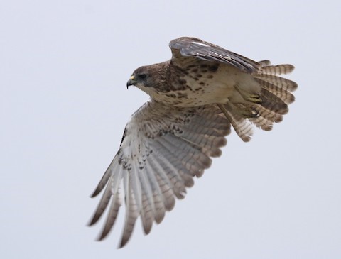
Hawaiian Hawk photographed along Keanakolu Road. © Alan Schmierer
The Kaumana Trail was once the principal land route across the center of the Big Island—the original Saddle Road—but most of it has long since been buried under lava or lost to natural changes in the landscape. There are several old roads in the vicinity of the parking area, but the most productive segment of the Kaumana Trail to walk is on the south side of Saddle Road and runs mostly west for about a half-mile.
Pu’u Huluhulu. The most significant junction along Saddle Road is where it meets the Mauna Kea Access Road, which departs northward up the mountain to the state park and visitor center (see below). This road also accesses Keanakolu Road, which leads eventually to Hakalau Forest National Wildlife Refuge. Opposite the junction on the south side of Saddle Road is a small hill, the Pu’u Huluhulu cinder cone, where there is a parking area and a short trail. There are a few other trails and roads (including the southbound Mauna Loa Observatory Road just below the east side of Pu’u Huluhulu.
Pu’u Huluhulu is at around 6,550’ elevation, a little lower than the high-point of Saddle Road, and the surrounding habitat is a mix of bare lava, grassland, and brush, with a few trees. The birdlife include a few native songbirds—mainly Hawaii Elepaio, Oma’o, Apapane, and Common Amakihi—as well as a few open country species, such as California Quail, Erckel’s Francolin, Kalij Pheasant, Wild Turkey, Hawaiian Hawk, “Hawaiian Short-eared Owl”, and Eurasian Skylark. Many of these are more likely to be found by exploring the road up Mauna Kea.
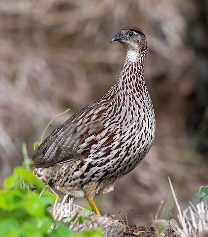
Erckel’s Francolin is common at upper elevations of Saddle Road and Mauna Kea. © William Richards
Mauna Kea Access Road. The public portion of the Mauna Kea Access Road runs for 6.5 miles from Pu’u Huluhulu up to the visitor center and astronomical observatory offices at Halepohaku, gaining nearly 3,000’ in elevation, from 6,550’ to 9,200’. Birds sometimes seen along this road include Hawaiian Goose, California Quail, Wild Turkey, Chukar, Erckel’s Francolin, Common and Kalij Pheasants, Pacific Golden-Plover, “Hawaiian Short-eared Owl”, and Eurasian Skylark.
The area around visitor center is open woodland that consists largely of māmane trees, which are the Palila’s principal food source. This species has been found sporadically in the area, often right beside the visitor center, but also along the trails on its eastern side in the Halepohaku Area of Mauna Kea State Park, and along the first stretch of the Mauna Kea Humu’ula Trail, which departs from the northwestern corner of the observatory complex.
Services
Accommodations
The nearest cluster of hotels is in downtown Hilo about 20-25 minutes’ drive from the kipukas. Many are budget accommodations by Hawaiian standards, none more so than the Wild Ginger Inn Hotel & Hostel, 1-808-961-6502.
Other Hilo lodgings include:
Dolphin Bay Hotel, 1-808-935-1466
Grand Naniloa Hotel Hilo, 1-808- 969-3333
Hilo Hawaiian Hotel, 1-808-935-9361
Hilo Seaside Hotel, 1-808-935-0821
Reeds Bay Resort Hotel, 1-808-934-7277
There are also a handful of hotels more centrally located in the town of Waimea, about 45 minutes’ drive (32 miles) from Pu’u Huluhulu. Reasonable options there include:
Waimea Country Lodge, 1-808-885-4100
Kamuela Inn, 1-800-555-8968
For primitive accommodations along Saddle Road itself, 6.5 miles west of Pu’u Huluhulu, the site formerly known as Mauna Kea State Park, and more recently known as either Mauna Kea Recreation Area, Pohakuloa Cabins, or Gilbert Kahele Recreation Park, offers high-elevation lodging in the form of seven cabins and one large bunkhouse (the latter available for large groups). Disappointed guests have reported that these cabins are extremely primitive.
The cost of a cabin for up to six people is $75/night for Hawaii residents and $150/night for non-residents—plus a $250 security deposit. The cabins have kitchenettes with a few pots and pans, a microwave, and a mini-fridge. The elevation is approximately 6,500’, so nights are cold, and a sleeping bag would be a necessity. Cabins must be reserved at least 48 hours prior to arrival, the maximum stay is seven nights, and the check-in window is between 3:00 and 8:00 p.m.
Notes
Hazards & Hassles
Rough Walking. The trails along Saddle Road include many patches of extremely jagged lava. This treacherous substrate will tear up your footwear and any portion of your body unfortunate enough to hit it with any force. Sturdy hiking boots with ankle support are strongly recommended.
Weather. Temperatures vary widely during a typical day and afternoon fog is common, and often thick—so either be prepared to follow your breadcrumbs back to your vehicle or plan an alternative means of navigation.
Links