Ka’ena Point, Oahu, Hawaii

Ka’ena Point offers unique access to a seabird colony, where large numbers of nesting Laysan Albatrosses and Wedge-tailed Shearwaters are protected from mammalian predators by a specially constructed fence, with gates for visitors to enter the colony. Several other seabirds are often present, including: Yellow-billed and Red-tailed Tropicbirds; Black-footed Albatross; Great Frigatebird; Red-footed, “Forster’s”, and rarely Masked Boobies; Brown and “Hawaiian” Noddies; and rarely Gray-backed Tern. It is also among the few consistent sites in Hawaii for Yellow-faced Grassquit.
Orientation
Directions
Ka’ena Point is the westernmost tip of Oahu, about an hour’s drive (40 miles) west of Honolulu, or 50 minutes (35 miles), from Hawaii’s largest airport, Daniel K. Inouye International.
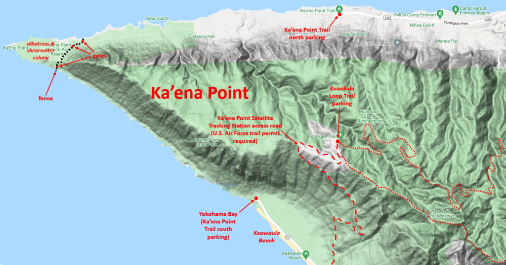
The point itself lies beyond the road system, but can be reached by either of two trails which are approximately equidistant from Honolulu. The two access points are on opposite sides (north and south) of a mountainous peninsula (the end of the Wai’anae Range), about a mile apart in straight-line distance, but the driving distance between them is over fifty miles.
From the South, via Wai’anae. Starting from the airport, take the main freeway, H1, north and remain on it as it winds west around Pearl Harbor. Shortly after passing Kapolei, the H1 freeway narrows and joins Highway 93, then bends north along the western coast of Oahu. Continue to the end of the road.
From the North, via Waialua. Take the H1, northwest to Pearl City, then keep right to head north on the H2. Continue on the main highway, which changes its route number to 99 then 803 as passes Schofield Barracks. Six miles farther, just before Waialua, the route number changes to 930. Continue another eight miles to the end of road.
Birdfinding
Ka’ena Point is the remotest part of Oahu, as far from Honolulu as it is possible to go without leaving the island. The wild and natural character of the area has been preserved by a policy decision to decommission a 4.5-mile segment of the Farrington Highway, leaving Ka’ena Point at the end of two dead-end roads. Most of the land near Ka’ena Point is publicly owned and dedicated to conservation in perpetuity.
The main attraction is Ka’ena Point Natural Area Reserve, the outermost 59 acres of Ka’ena Point, which protects one of the world’s most accessible albatross breeding colonies. Effectively isolated by a well-constructed fence, the reserve remains open to the public. Counts in the late 2010s exceeded 100 pairs of Laysan Albatrosses and 1,500 pairs of Wedge-tailed Shearwaters, along with a few pairs of Yellow-billed Tropicbirds.
Visitors might also consider venturing up into the network of hiking trails that traverse the northern reaches of the Wai’anae Range, where Oahu Amakihi occurs occasionally, and there are small populations of Kalij Pheasant, Indian Peafowl, and Chinese Hwamei, all of which are scarce and localized on Oahu. Trails into the Kuaokala Forest Reserve are most accessible from the southern approach to Ka’ena Point via the military base beside Keawaula Beach, as described below.
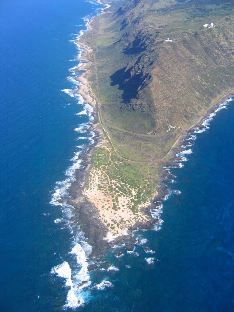
Ka’ena Point, aerial view from the west. Hawaii Department of Land and Natural Resources
Ka’ena Point Natural Area Reserve. The Ka’ena Point Trail follows the shoreline between what are now the two dead-ends of the Farrington Highway. Approaching from either end, the hike to the reserve is a little over two miles. The trail from the north side is about a quarter-mile longer than the southern one. However, the southern route is not always drivable to the end of the road, so either approach could turn out to be longer than the other.
The outer portion of Ka’ena Point is partially vegetated dunes. The construction of a predator-proof fence in 2011, combined with the removal or eradication of mongooses, rats, mice, and feral cats and dogs, enabled the restoration of the native dune vegetation and protected a beleaguered colony of Laysan Albatrosses, Wedge-tailed Shearwaters, and Yellow-billed Tropicbirds.
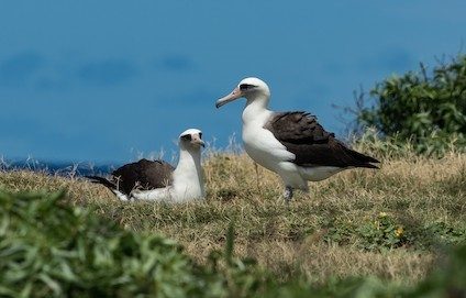
The Laysan Albatross colony at Ka’ena Point is among the most accessible albatross colonies in the world. © Forest Jarvis
With protection, the colony has expanded and is likely to continue to grow in numbers and diversity. During the 2010s, Black-footed Albatrosses became increasingly regular and seemed poised to begin nesting among the Laysans. Red-tailed Tropicbirds are often present between April and August, and might also begin nesting, if they haven’t already. The colony also hosts a few nonbreeding Great Frigatebirds and Red-footed and “Forster’s” Boobies, and more sporadic visitors include Masked Booby, Common Fairy-Tern, Brown and “Hawaiian” Noddies, and Sooty and Gray-backed (mostly in March and April) Terns.
Kaena Point is also among the better locations for observing Hawaiian Monk Seals, which often haul out on the beach, and Humpback Whales near shore in the winter months.
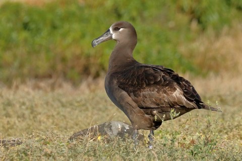
In the mid-2010s, Black-footed Albatrosses began visiting the Laysan Albatross colony at Ka’ena Point. © Sharif Uddin
Along the trail, watch the grass and scrub for three species of francolin: Black, Gray, and Erckel’s. Around the southern trailhead, the scrubby area beside Keawaula Beach—which lies within Ka’ena Point State Park—is one of the few areas on Oahu where Yellow-faced Grassquit has been found consistently in recent years.
Kuaokala Forest Reserve. When approaching Ka’ena Point from the south, about three quarters of a mile before the pavement ends, at the south end of Keawaula Beach, a paved side-road heads up to the U.S. Air Force’s Ka’ena Point Satellite Tracking Station, and also provides access to the Kuaokala trail system. A free day-use permit, obtained online in advance, is required for visitors to hike the trails, and also authorizes permittees to drive the military road to reach the trailhead—see Kuaokala and Mokuleia Forest Reserve Access via Kaena Point Tracking Station.
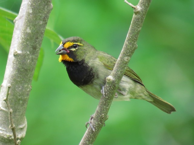
The Yellow-faced Grassquit is generally uncommon on Oahu, but can sometimes be found in the scrub behind Keawaula Beach. © Mark Salvidge
The ragged, hilly landscape above Ka’ena Point falls under a patchwork of public ownership. Most of it is state property managed for the various recreational and conservation uses of Ka’ena State Park, Kuaokala Game Management Area, and Kuaokala Forest Reserve. A small but prominent portion is federal property where the Air Force maintains a satellite-monitoring observatory. The government agencies share rights of way, but the Air Force controls the only paved access road.
Immediately after turning east on the access road is a gate and guard shack, where you will need to show your permit, vehicle registration, and identification for everyone in the vehicle. The policies and protocols in effect may vary, but do not be surprised if they require you to have a military vehicle escort beyond this point.
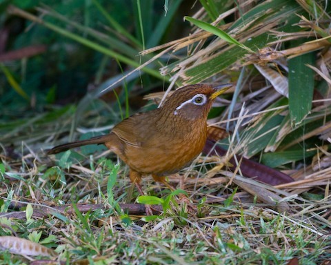
The Chinese Hwamei has become rare in eastern Oahu, but still thrives in the Wai’anae Range. © Todd Dixon
Drive up the hillside to a second gate and guard shack at the top of the ridge. Turn right and go about a half-mile to the trailhead parking area. The main segment of the Kuaokala Trail follows the ridgeline southeast, but there are several options, including a 7-mile loop.
Services
Accommodations
Most of Oahu’s hotels are concentrated in Waikiki, about 45 miles southeast of Ka’ena Point. There is another, smaller cluster of resort hotels at Ko Olina, about 20 miles south of Ka’ena Point.
Notes
When to Visit
Laysan Albatrosses are present at Ka’ena Point mainly from November to July, Wedge-tailed Shearwaters mainly from March to November, so the colony is most active from March to July.
Links