Makiki, Oahu, Hawaii

The hills overlooking downtown Honolulu are popular for day hikes and panoramic views of the city. The most efficient way to reach this area is via Tantalus Drive. Both of Oahu’s surviving honeycreepers, Apapane and Oahu Amakihi, can sometimes be seen there—the latter more consistently than the former. It is also among the most accessible places to find certain introduced species, such as White-rumped Shama, Red-whiskered Bulbul, and Red-billed Leiothrix.
Orientation
Directions
Makiki is a district of Honolulu that extends northeast from downtown, about 10 minutes’ drive (6 miles), traffic permitting, from Hawaii’s largest airport, Daniel K. Inouye International. There are two routes up to the Makiki Hills—Tantalus Drive and Round Top Drive—which form a circuit.
To Tantalus Drive. From the airport, take the main freeway, H1, east for about 5 miles to Exit 21A, the Pali Highway (also Highway 61). At the end of the exit ramp, turn left (north) onto the highway, but keep right and take the first exit onto Kuakini Street.
After one long block, Kuakini Street ends at Lusitana Street. Turn left onto Lusitana, then immediately right onto Concordia Street. After one long block, Concordia Street ends at Puowaina Drive, with a geological formation called the Punchbowl (a crater with an elevated outer rim) looming ahead.
Remain on Puowaina Drive as it skirts around the northern side of the Punchbowl into the lower part of Makiki. After about a half-mile, Puowaina makes a right-angle turn, but the same roadway continues straight, and becomes Tantalus Drive, which is the main route up into the hills of Makiki.
To Round Top Drive. From the airport, take the main freeway, H1, east for about 7 miles to Exit 23, Punahou Street. At the end of the exit ramp, turn left (north) onto Punahou. After 0.4 miles, turn left onto Nehoa Street, then take the second right north onto Makiki Street. Almost immediately, Makiki Street forks.
The left fork is Makiki Heights Drive, which leads to the Hawaii Nature Center, Makiki Arboretum, and Makiki Valley State Recreation Area (with hiking trails). Makiki Heights winds uphill and joins the lower part of Tantalus Drive.
The right fork is Makiki Street, which almost immediately forks again. The right fork is a dead-end. The left is Round Top Drive, which winds up into the hills and joins Tantalus Drive after several miles.

View of Diamond Head from Pu’u Ualaka’a. © The Elevated Moments
Birdfinding
Makiki is largely coextensive with the Makiki Valley watershed—a high flank of the Ko’olau Range that remains largely forested and preserved as public land. A scenic loop road winds around the valley, keeping near the main ridges on either side. On the western ridge the road is Tantalus Drive, and on the eastern ridge it is Round Top Drive. There is an additional access point between the ridges, on the valley floor at the Hawaii Nature Center, which is the trailhead for a small network of trails.
Tantalus Drive. Birdwatchers who know the area well generally seem to prefer Tantalus Drive. In particular, there is a pullout in the second set of hairpin turns, 2.8 miles uphill from the foot of Tantalus Drive. This provides limited parking for the nearby Makiki Valley Trail and for walking along this stretch of Tantalus Drive, which is often productive.

Male Oahu Amakihi along Tantalus Drive. © Nick Kalodimos
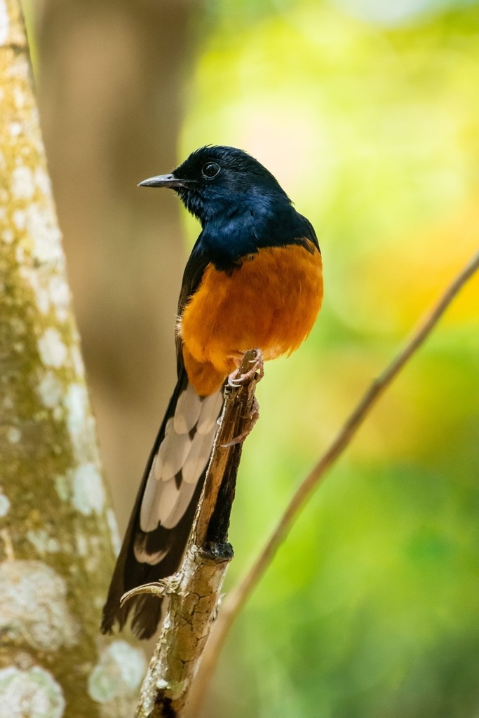
The main target for most visiting birdwatchers is Oahu Amakihi, which is not always easy to find but probably occurs throughout the year. The other honeycreeper, Apapane, occurs more sporadically. Most of the other species present are introduced, notably: Rose-ringed Parakeet, White-rumped Shama, Red-vented and Red-whiskered Bulbuls, Warbling White-eye, Red-billed Leiothrix, Common Waxbill, and Red-crested Cardinal.
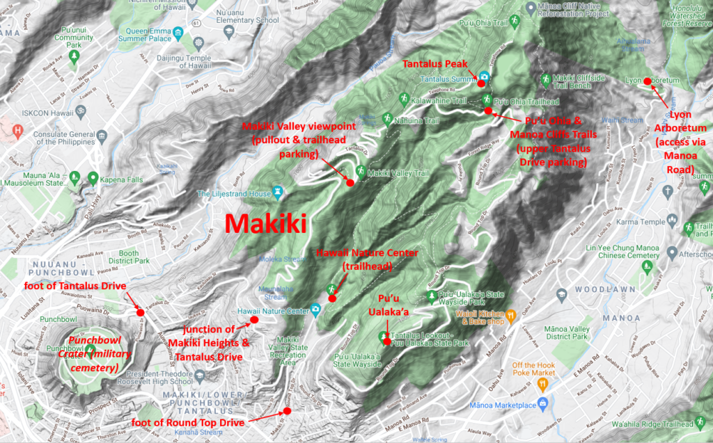
Another area where it is usually possible to park and walk is 1.7 miles farther (4.5 miles from the start) at the upper end of Tantalus Drive. This is the main trailhead for the Pu’u Ohia Trail and a network of connected trails including Makiki Cliffs, which overlooks the Manoa Valley and Lyon Arboretum to the east. A short hike up the Pu’u Ohia Trail brings you to Telephone Road and the side trail to Tantalus Peak.
Round Top Drive. The same birds also occur on the Makiki Valley’s eastern ridge, along Round Top Drive, which is the continuation of Tantalus Drive past the Pu’u Ohia Trail area, returning via Pu’u Ualaka’a State Park. The most prominent feature of this ridgeline is Pu’u Ualaka’a itself (a.k.a. Round Top), which juts into the city between the neighborhoods of Makiki and Manoa.
This popular viewpoint is accessed by a side-road 2.6 miles past the Pu’u Ohia Trail, just before the main road begins descending into the city (or, alternatively, just after Round Top Drive climbs up onto the ridge, for those who begin the loop on the eastern side).
Hawaii Nature Center. To visit the lower Makiki Valley, take Makiki Heights Drive—which connects the lower ends of Tantalus and Round Top Drives. At the points where it extends deepest into the valley, Makiki Heights makes a hairpin turn, and a short side-road continues deeper. This leads into the Makiki Arboretum and a small compound of buildings associated with the arboretum and the Makiki Valley State Recreation Area.
One of the buildings is the Hawaii Nature Center, https://hawaiinaturecenter.org/, an outdoor education facility that provides programs for schoolchildren and other types of community groups, where visitors can pick up trail maps or use the bathrooms.
A short trail parallels the access road through the arboretum. At the end of the road is the main trailhead for the lower valley. The Kanealole Trail stays near the valley floor, while the Na Ala Hele-Maunalaha Trail climbs up the eastern side of the valley toward Pu’u Ualaka’a. The two trails eventually connect to form a loop, and also connect to the extensive trail network of the Makiki Valley, including all the other trails mentioned above.

This popular viewpoint is accessed by a side-road 2.6 miles past the Pu’u Ohia Trail, just before the main road begins descending into the city (or, alternatively, just after Round Top Drive climbs up onto the ridge, for those who begin the loop on the eastern side).
Services
Accommodations
Honolulu has an abundance of accommodations concentrated in Waikiki, a few miles south of Makiki.
Notes
Hazards & Hassles
Anyone planning to hike the trails of the Makiki Valley should dress for muddy conditions and bring insect repellent for the often-abundant mosquitoes.
Links