Cabo Rojo National Wildlife Refuge, Puerto Rico
Cabo Rojo is a windswept headland at the tip of an oddly shaped peninsula that juts into the Caribbean Sea at the southwestern corner of Puerto Rico. The refuge that bears its name encompasses nearby tracts of mangroves, tidal flats, scrub, and dry forest that support the largest diversity of bird species of any site in Puerto Rico, including the localized and endangered endemic Yellow-shouldered Blackbird.
Orientation
Directions
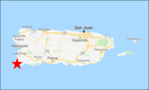
Cabo Rojo NWR is about two and a half hours’ drive (185 km) southwest of San Juan, an hour (75 km) west of Ponce, or 30 minutes (30 km) south of Mayagüez.
Access is via rural highways south of the town of Cabo Rojo and west of La Parguera. Arriving from any direction, the key junction is where PR-301 and PR-303 meet—the side road to the headquarters office and interior sector is on PR-301 about 1 km west of this junction, and the peninsula is 9 km further along PR-301.
From the North. Coming the direction of Mayagüez, the roads are straightforward. Exit the main highway, PR-2, onto PR-100, which joins PR-301 and leads to the refuge.
From the East. Coming from the direction of Ponce and San Juan, the quickest route to Cabo Rojo is to exit at Guánica on PR-116. After 21 km, turn left onto PR-202, go 2.3 km, turn left onto PR-303, then go 12 km to its junction with PR-301.
Attractions
Combate Beach. A side-road between the refuge headquarters and the peninsula leads to the popular Combate Beach, a two-mile strand. The north end of the beach is often crowded on weekends, but the south end remains peaceful and empty.
Boquerón Wildlife Refuge. 5 km north of Cabo Rojo refuge headquarters, a side-road from PR-301 leads into the Boquerón refuge, which protects an extensive mangrove swamp, brackish lagoons, freshwater wetlands and fields. A 4-km dyke road a boardwalk trail provide convenient access to much of the habitat. Bird diversity at Boquerón is among the highest of any site in Puerto Rico.
Laguna Cartagena NWR. 20 minutes’ drive northeast of Cabo Rojo NWR brings you to another property of the U.S. Fish & Wildlife Service, the outstanding Laguna Cartagena, which is rife with waterbirds, including sizeable populations of West Indian Whistling-Duck, White-cheeked Pintail, Masked Duck, and several species of heron.
La Parguera. The seaside town of La Parguera, 20 km east of Cabo Rojo NWR, is popular among Puerto Ricans for weekend recreation and well known to birdwatchers for its resident flock of Yellow-shouldered Blackbirds and convenient accommodations.
Birdfinding
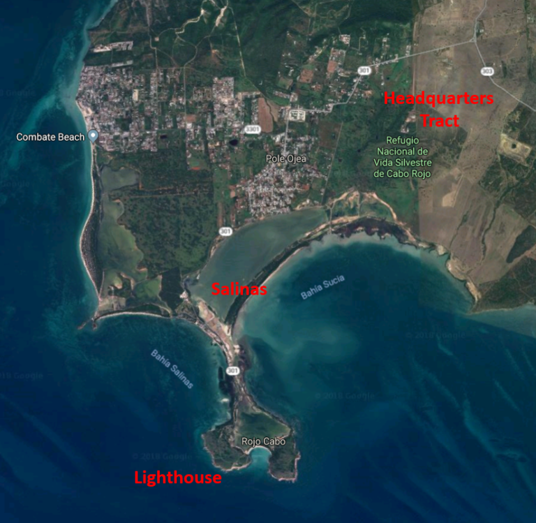
The protected areas of Cabo Rojo are extensive and include Cabo Rojo National Wildlife Refuge and Los Morrillos de Cabo Rojo (the peninsula and lighthouse area, administered by the Puerto Rico Department of Natural and Environmental Resources). The areas that are developed for visitors (i.e., with parking lots and trails) are the refuge headquarters area and Morrillos de Cabo Rojo. The 9 km road between these areas passes beside extensive salt flats (“salinas”).
Refuge Headquarters. The inland tract of Cabo Rojo NWR has an extensive trail system through fairly diverse habitats, from dense brush to open fields, with some small freshwater ponds. This area is especially productive for flycatchers, with Caribbean Elaenia, Puerto Rican Pewee, Puerto Rican Flycatcher, Gray Kingbird, and Puerto Rican Kingbird all common. Exotic species often present include Venezuelan Troupial, Orange-cheeked Waxbill, Bronze Mannikin, Indian Silverbill, and Pin-tailed Whydah.
Cabo Rojo National Wildlife Refuge and environs.
Other species to be found in the headquarters tract include Mangrove Cuckoo, Antillean Nighthawk, Puerto Rican Mango, Puerto Rican Emerald, Puerto Rican Tody, Puerto Rican Woodpecker, “East Caribbean Kestrel,” and Adelaide’s Warbler.
The Salinas. The road from the headquarters to the Cabo Rojo peninsula passes beside a large lagoon and a series of salt pans that range from bone-dry to ankle-deep, depending on weather trends. Shorebirds are present year-round, with lower numbers and diversity in the summer: i.e., May to July, when most shorebirds are on their breeding grounds.
Cabo Rojo Peninsula. The Cabo Rojo Peninsula juts more than a mile out of the main coastline at the southwesternmost point of Puerto Rico, which makes it a natural aggregation point for migrating birds. Southbound birds can go further without crossing open water. High bluffs (and a lighthouse) make it highly visible from sea, so for many northbound birds it will be the first point of land they find after crossing the ocean. The peninsula includes a combination of terrestrial and aquatic habitats where migrants can feed before or after a long flight over the Caribbean Sea.
Los Morillos Lighthouse. Near the end of the road, there are two parking lots. Most visitors park in the first one because it is conspicuous and seems to provide the shortest path to the lighthouse—but this is wrong. As you arrive at that parking lot, turn left and drive approximately 500 m toward the “playuela,” where there are many places to park. This is closer to the lighthouse and to most other points of interest on the peninsula.
The Cabo Rojo lighthouse, Faro los Morillos, is perched atop impressive, picturesque cliffs. Brown Booby is usually present, and from January to May, or so, a few pairs of “Atlantic White-tailed Tropicbird” nest on the cliffs and can often be seen at fairly close range.
The Lagoon and Playuela. The second parking area is adjacent to the large lagoon that occupies the interior of the Cabo Rojo peninsula. The lagoon itself often has flocks of shorebirds and terns. Yellow-shouldered Blackbird and “Caribbean Clapper Rail” can often be found along the edges of the lagoon.
Services
Accommodations
…
Food
…
Notes
…