Kaeng Krachan National Park, Phetchaburi, Thailand
Thailand’s largest national park forms part of a more extensive complex of protected areas that straddle the border with Myanmar. Kaeng Krachan is ecologically intact, mostly inaccessible, and large enough to support healthy populations of Asian Elephant, Gaur, Sun Bear, and other large mammals. Its avifauna is diverse enough to place it in the top tier of birdwatching sites in Thailand. It is especially well-known for broadbills (seven species: Green, Black-and-red, Long-tailed, Silver-breasted, Banded, Black-and-yellow, and Dusky) and Rusty-cheeked Hornbill, which is fairly common here and rarely found anywhere else.
Orientation
Directions
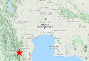
Kaeng Krachan National Park is about two and a half hours’ drive (190 km) southwest of downtown Bangkok, in the hills west of Phetchaburi.
From Bangkok, take Route 35 west for 85 km, where it feeds into Route 4. Take the southbound exit toward Phetchaburi then proceed 21 km and exit onto Route 3349 westbound. After 17 km, turn south onto Route 3510, then follow the signs to the park, bearing right at a couple of forks around 36 km onto Route 3432.
After 12 km on Route 3432, bear left at the fork to reach the park entrance in another 2 km. If you bear right instead, you will remain on Route 3432 into Song Phi Nong and eventually the national park headquarters—instead of the park itself.
Birdfinding
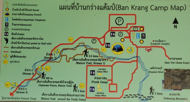
Kaeng Krachan National Park is a very large area with far too many avian highlights to discuss in full. For planning purposes, however, Kaeng Krachan is comprehensible as consisting of three main segments: (1) the lower park; (2) the upper park; and (3) the eastern periphery—this last area is covered separately as Song Phi Nong. The three segments differ dramatically in their conditions of access, and prospective visitors should consider them individually.
The “lower park” is what most people have in mind when they refer to Kaeng Krachan National Park. It consists of the areas that are readily accessible along the main park road from the entrance gate to Ban Krang Campground and the trails and roads that are within easy walking distance beyond Ban Krang.
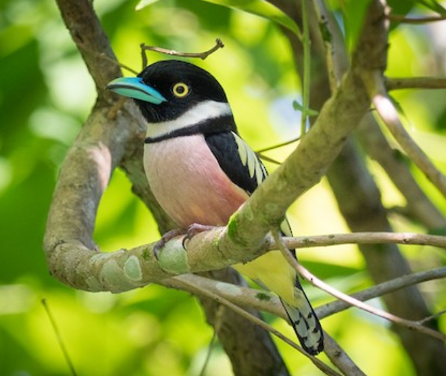
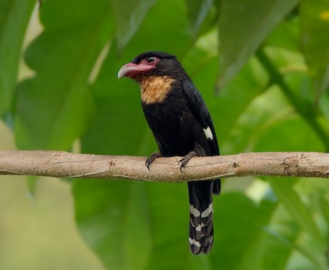
Black-and-yellow Broadbill. Anonymous eBirder
The “upper park” is the increasingly inaccessible interior of the park along the main park road from the point where it goes steeply uphill (about 3 km past Ban Krang) to the end of the road, including the environs of Panoen Thung Campground. Access to the upper park has long been limited by road conditions, and since 2018 by a formal closure. The closure is not intended to be permanent, but as of early 2020 its end-date was uncertain. During the closure, visits are generally prohibited, although the road remains open to park and military vehicles.
Lower Park. The main park entrance is open daily from 8:00 to 17:00, upon payment of moderate per-person and per-vehicle fees. The main road from the entrance gate to Ban Krang Campground is a well-maintained 15-km ribbon of asphalt that passes through rolling hills that are mostly covered in deciduous forest. Then, starting from Ban Krang, there are a handful of options to explore the evergreen forest.
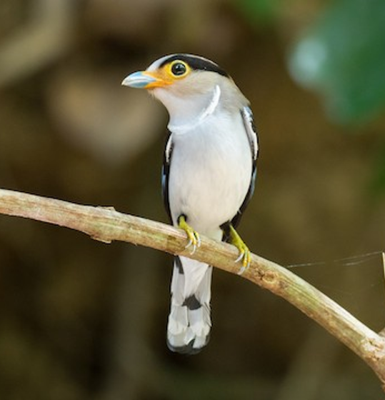
Silver-breasted Broadbill. Anonymous eBirder
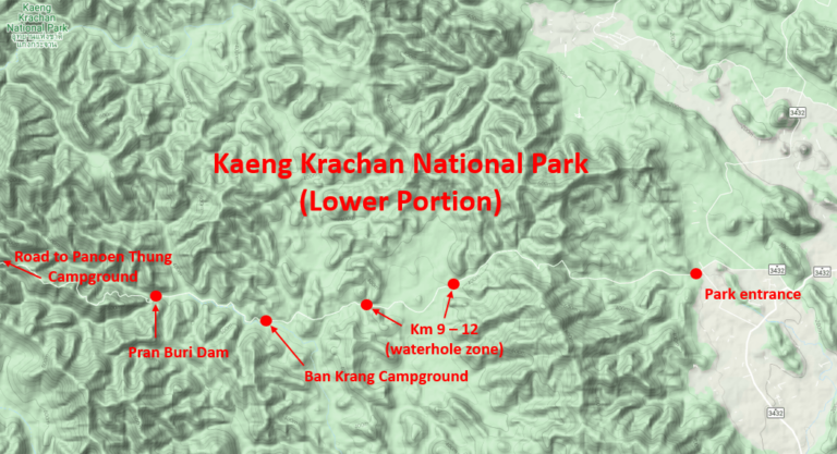
Entrance Road and Waterholes: As is generally the case throughout Kaeng Krachan, anywhere along the road from the entrance gate to Ban Krang is potentially interesting. One particular area that offers better prospects than the rest is the stretch from km 9 to km 12, where the road passes among a series of waterholes that attract a wide array of birds, with a few large mammals sometimes appearing around dusk. Visitors with limited time should plan to focus on this part of the road.
In the stretch that begins at km 9, the waterholes are close together, and the areas in between are mostly open with a few tall trees that regularly attract Thick-billed Green-Pigeon, Great and Oriental Pied Hornbills, Greater Flameback and sometimes other woodpeckers, Common Hill and Golden-crested Mynas. This is a likely area to find Rusty-cheeked Hornbill and a few other specialties of the park, including Blue-bearded Bee-eater, Black-thighed Falconet, and Black-and-red Broadbill. A visit to this area around dusk adds the possibility of seeing large mammals, especially Asian Elephant and Gaur, and a solid chance of both Large-tailed and Great Eared Nightjars.
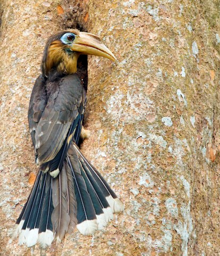
Rusty-cheeked Hornbill is a specialty of Kaeng Krachan National Park that is hard to find anywhere else. Within the park it often appears in the waterhole zone between km 9 and km 12. © Marco Valentini
Ban Krang Campground: Most of the same species also occur in and around Ban Krang Campground, and can sometimes be found more easily there. As you enter the campground you will see a road that forks north and immediately fords a creek (actually the Pran Buri River), leading to the “Youth Camp.” This area is worth exploring, especially if it is unoccupied. Even if the Youth Camp is occupied, there is a track around it that gives access to a large swath of forest.
The campground area as a whole is a good place to search for nightbirds, most notably White-fronted Scops-Owl, which has occurred sporadically. More widespread species often found here include: Oriental Bay Owl, Asian Barred and Collared Owlets, Brown Boobook, Collared Scops-Owl, and Large-tailed and Great Eared Nightjars.
From dusk till dawn, visitors should be cautious and alert to the possible presence of large, potentially dangerous mammals, such as Asian Elephant and Leopard. (The author spent a single night at the campground, in which a Leopard was seen by others soon after dusk and at dawn the author had a close but harmless encounter with a startled Asian Elephant.)
Kaeng Krachan park sign. © Russell Fraker
Road to Pran Buri Dam: Vehicular access to the main road is currently (as of early 2020) blocked by a gate at the western end of Ban Krang, but the road is open for exploration on foot, and visitors should plan to do this. The first three km or so of the road beyond Ban Krang, until reaching the small Pran Buri Dam, is mostly level and passes through tall evergreen forest that was selectively logged in the distant past, but has largely regrown.
The road follows the Pran Buri River—which is a shallow creek or stream in the dry season—and crosses it at three fords (not bridges). When private vehicles are allowed past Ban Krang, these fords are a limiting factor—crossing them in a typical passenger car is usually possible in the dry season, but always a little risky, and unwise to attempt if the flow is much higher than its seasonal low. Under dry season conditions, it is usually possible to cross all three fords on foot, rock-to-rock, without getting wet.
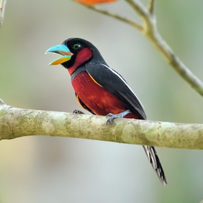
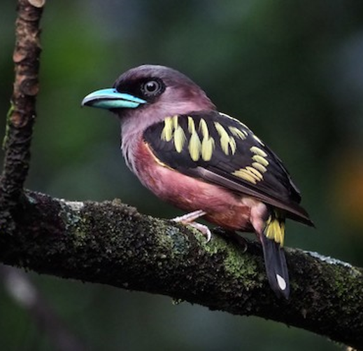
Black-and-red Broadbill. © Paul Maury
Along the road to the Pran Buri Dam a wide array of interesting birds—some spectacular species among them—are possible, including: Grey Peacock-Pheasant, Orange-breasted Trogon, Rusty-cheeked Hornbill, several woodpeckers (Rufous, Buff-rumped, Crimson-winged, Banded, Heart-spotted, and Great Slaty), and Common Green-Magpie.
In spring and summer, several species likely to be of interest to many visitors either return from wintering grounds or become more conspicuous. These include kingfishers (Banded and Black-backed Dwarf-), broadbills (Silver-breasted, Banded, Black-and-yellow, and Dusky), and pittas (Blue, Blue-winged, Hooded, and Eared), and Crested Shrike-Jay.
Dusky Broadbill. © Ayuwat Jearwattanakanok
Nature Trail: At the western end of the campground there is a trailhead identified simply as the “Nature Trail.” This trail meanders along the Pran Buri River valley and joins the main road after about 2.5 km, between the first and second fords mentioned above.
Unlike the road, the trail is not level, and in a few places it becomes indistinct, so hikers should be attentive to avoid getting lost on a side-trail. Along most of its length, the trail remains close to the river bed, and it provides a higher probability than the road of finding certain birds, especially the kingfishers and pittas.
Pakarang Mountain Trail (Guided Hikes Only): A more challenging trail departs from the southeasternmost point of the “Youth Camp” track mentioned above and climbs a hill called Pakarang Mountain. The park administration requires that visiting hikers be accompanied by a park-approved guide—the main fear being that a visitor will get lost or injured, which are serious risks in this area. The Pakarang Mountain Trail is best known for Spot-bellied Eagle-Owl, which has nested along it, but this is not a constant presence and an unguided visitor is not likely to find it.
Banded Broadbill. © Paul Sullivan
Upper Park. Even under the best of conditions, the road past Ban Krang is not safely drivable without a high-clearance vehicle. This is due to a series of difficult patches, each of which could probably be negotiated by a skilled driver with local knowledge—but collectively they present a formidable and perhaps insurmountable challenge, and it would be unwise to attempt this drive in a sedan, especially a rental. This situation may change after the planned roadwork, but that remains to be seen.
Once the official closure ends (if and when it does), visits to the upper park will entail research into the road conditions and appropriate planning. To check for changes in the status of the closure, visit the Kaeng Krachan National Park website. Due to the uncertainty of future access, the site description provided here is brief—a more detailed account is available at ThaiBirding.
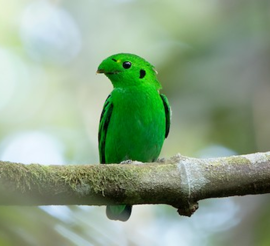
Green Broadbill, the rarest of the seven broadbill species found at Kaeng Krachan. © Ayuwat Jearwattanakanok
Lower Foothill Road: The lower portion of the road, as it climbs into the foothills above the Pran Buri Dam, is accessible on foot from Ban Krang Campground. Although officially this may violate the closure, there is no clearly specified point that visitors are prohibited from passing (none that were visible to the author, in any case). Unless this changes, a day-hiker could hike about halfway from Ban Krang to Panoen Thung—to the vicinity of km 24 or 25—and return by mid-afternoon.
This opens the possibility of finding some additional species that rarely if ever occur at the park’s lower elevations, including Black Eagle, Wedge-tailed Green-Pigeon, Red-headed Trogon, and Long-tailed Broadbill. Pressing a little farther would increase the odds of finding some of the species that are common higher up, including Ratchet-tailed Treepie, although at some point continuing becomes unwise.
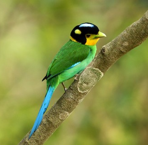
Long-tailed Broadbill is found mainly at middle and upper elevations of Kaeng Krachan. © Kalyan Singh Sajwan
Upper Foothill Road: The upper portion of the road, as it approaches Panoen Thung Campground, is reportedly very productive, with Ratchet-tailed Treepie becoming fairly common starting around km 27. Around this transitional area, a more montane avifauna predominates, with dozens of species that do not occur in the lower portion of the park, including: Yellow-vented Green-Pigeon, Mountain Imperial-Pigeon, Red-bearded Bee-eater, Great Barbet, Speckled Piculet, Rusty-naped Pitta, Grey-chinned Minivet, White-throated Fantail, various babblers (Collared, Golden, Buff-breasted, Grey-throated and Spot-necked), Rufous-browed Flycatcher, and Silver Oriole.
Panoen Thung Campground: When the park interior is open to visitors, Panoen Thung Campground, is their primary destination. Located about 30 km from the park entrance, it has a restaurant, bathrooms, campsites (obviously), scenic overlooks, and a nature trail. Additional species that have reportedly been seen regularly in this area include: Mountain Hawk Eagle, Rufous-bellied Eagle, Blue-throated Barbet, Blyth’s Shrike-babbler, Grey Treepie, Flavescent and Mountain Bulbuls, Black-throated Laughingthrush, Orange-bellied Leafbird, Fire-breasted Flowerpecker, Streaked Spiderhunter.
Beyond Panoen Thung Campground: The road continues for another 6 km or so past the campground, then arrives at the Tortip Waterfall Trail. The last stretch of the road is especially scenic and productive for raptors, including Mountain Hawk Eagle and Rufous-bellied Eagle. Bamboo stands in the area are noted for Pin-tailed Parrotfinch.
Services
Accommodations
Within the park, Ban Krang Campground is available for camping, and has showers and related facilities. There are no assigned sites and no specific limitations, but you must check in with the campground manager (if you don’t, he will probably track you down and ask you to explain your plans). If you have your own tent, you can simply set it up on an unoccupied patch of lawn. If you prefer to sleep in your car, that is also allowed. If you would like to rent a tent and sleeping bags, they are available from the campground manager on a first-come-first-served basis.
Assuming that it eventually reopens, Panoen Thung Campground is reportedly more comfortable than Ban Krang—and presumably somewhat cooler overnight. The policies appear to be the same as at Ban Krang.
Just a few hundred meters outside the park entrance gate, Samarn Bird Camp (email: nuchanat@set.or.th) is a moderate-to-budget-priced guesthouse that caters to those who would like to visit the park but also sleep in a bed.
Fifteen minutes (10 km) farther from the entrance gate, Baan Maka Nature Lodge has several cabins on a secluded property that is attractive to people and birds.
Food
There are small, open-air restaurants at both Ban Krang and Panoen Thung. On weekdays there are very few patrons and on weekends they sometimes run out of food, so it is generally a good idea to check in with them and order before dark if you don’t want to risk skipping dinner.
Notes
When to Visit
There are several factors to consider when scheduling a visit to Kaeng Krachan National Park. Most importantly, the entire park closes each year for the months of August, September, and October. During the rest of the year, the entrance gate is open daily from 6:00 to 17:00. (Those already inside the park can leave as late as 19:00.) The entry fee is 300 baht per person, plus a nominal per-vehicle fee.
Second, the interior of the park, past Ban Krang Campground closed to the public in 2018 for large-scale road repairs and other planned construction. It was intended to reopen in 2020, but a lawsuit has suspended those activities, and as of early 2020 the timing of its eventual reopening appears to be in doubt. Consult the Kaeng Krachan National Park website for updated information about public access. In the past, when the interior was open, the road between Ban Krang and Panoen Thung was restricted to one-way travel during certain times of day, alternating between uphill and downhill.
Third, it is best to avoid weekends and holidays to the extent possible. On weekdays the park is often nearly empty of visitors, and most of the few who are present are usually engaged in some quiet pursuit of nature study. On weekends and holidays, the volume of visitors is much higher, sometimes by a large multiple, putting many more vehicles on the main road and noisy groups of hikers on the trails.
Finally, the birds that can be expected change with the seasons. In the dry season, from November to February, northern migrants occur in large numbers and many of the resident species become reclusive. From March onward, the odds of seeing kingfishers, broadbills, and pittas are higher.
Hazards & Hassles
Large Dangerous Animals. Kaeng Krachan has significant populations of large mammals that can be dangerous, especially Asian Elephant. As a general rule, wild elephants want no interaction with humans and they remain away from well-traveled areas during the day. From dusk to dawn, however, they wander more widely and often emerge, cross roads, and visit waterholes, which can lead to inadvertent encounters.
Road Conditions. The main park road from the entrance to Ban Krang is suitable for any kind of vehicle. Beyond Ban Krang, it is suitable for high-clearance vehicles. There are three fords, each of which could be passable during the dry season, but might sometimes hide unseen hazards. Just past the Pran Buri Dam, the road turns steeply uphill and goes through several areas where it can become rocky and deeply rutted, depending on recent weather and the state of its maintenance.
Links